
King County Neighbors by Block
Looking up King County neighbors begins with the shape of the block, not a list of people. Parcel Viewer can define nearby lots, the Assessor can identify each owner of record, and recorded plats can explain shared land. Those facts describe parcels and legal relationships. They do not establish who occupies each door today. Keep parcel, address point, owner, and community contact as separate columns.
| Source | What It Shows About a Block | Access |
|---|---|---|
| Parcel Viewer | Adjacent parcel shapes, PINs, situs addresses, and report links | Free public map |
| Assessor eReal Property | Owner of record, mailing address, legal description, and property details | Free web report |
| Landmark and recorded plats | Deeds, easements, covenants, and common-area links | Free index; copies may cost |
| Voter information | A properly matched individual's voter and ballot information | Direct lookup or regulated request |
| Community organizations | Public board contacts, service areas, and local programs | Public contacts, not rosters |
The sound result is a dated set of surrounding parcel numbers. An owner may receive tax mail elsewhere, and a nearby polygon may be a road, park, common tract, condominium parcel, or tax-exempt site. For a whole named street rather than one block, use the King County street directory workflow.
Define King County Neighbor Parcels
The King County Parcel Viewer accepts an address, parcel number, or condominium name. Search the subject address, click its parcel, then use Buffer or the line and area selection tools. Export the selected parcel information and save the map date. The viewer's lot lines are approximate and are not a legal survey.
| Control | Use on the block |
|---|---|
| Address or PIN | Fix the starting parcel |
| Map click | Select a visible adjoining lot |
| Buffer distance | Create a consistent radius in feet |
| Line or area select | Gather parcels along one block face |
| Export selected info | Keep the parcel set for review |
Open Parcel Viewer to see its search, selection, and report controls.
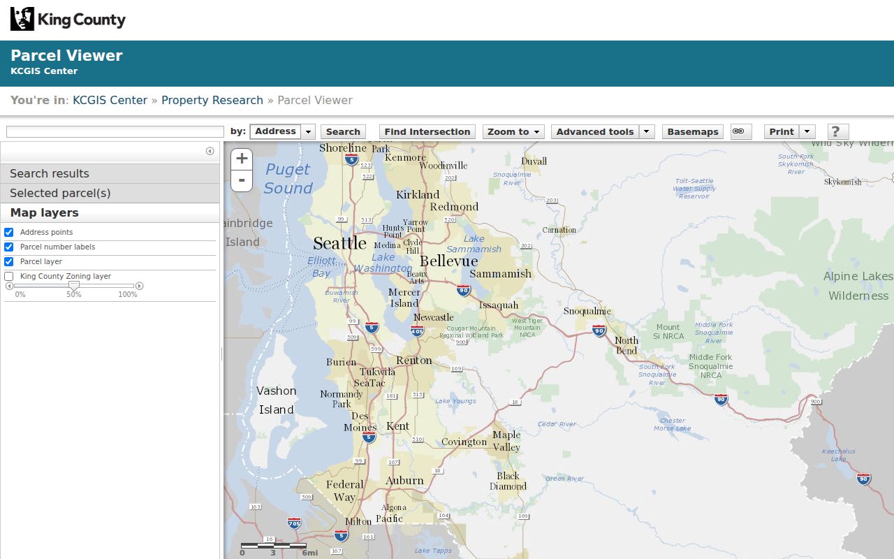
The map supplies the geographic starting set. Each PIN still needs its Assessor report and, where boundaries are unclear, a recorded plat or survey.
Map King County Neighbors Carefully
Move from geometry to names one source at a time. This process keeps an owner label from being mistaken for a resident count and preserves enough detail to repeat the search.
- Locate the situs address in Parcel Viewer. Situs is the parcel's physical location, while mailing address is used for correspondence.
- Select touching parcels or those in a stated buffer. Export PINs and situs addresses.
- Open each Assessor report. Record owner of record, mailing address, legal description, and parcel traits separately.
- Inspect plats, easements, covenants, and boundary adjustments in Landmark when lots share access or common land.
- Label the result neighboring parcels, not households. Save the date and selection method.
Condominiums may have one GIS address point, while duplexes and other small multi-unit sites may have several. Malls may also have several points. KCGIS derives address points from E911 sources, so point count cannot become a count of King County neighbors.
Read King County Neighbor Reports
The Assessor report adds owner, PIN, situs, mailing address, legal description, value fields, and property traits. A mailing address can be a post-office box, business, agent, or place outside Washington. It should not be presented as the owner's home without independent proof.
Recorded instruments add context. A deed ties parties to a transfer; a plat creates or divides lots; an easement grants a stated use; and a covenant can bind several parcels. Landmark's general online index covers most documents from August 1, 1991. Parcel-ID search is identified as 1997 forward, so an empty result may require an owner-name search or Archives microfilm.
- Parcel
- A mapped unit of land with a county identification number.
- Situs address
- The physical street location used for property and map records.
- Plat
- A recorded map laying out lots, streets, and common areas.
- Common area
- Land shared or managed for more than one parcel.
Note: Public parcel lines provide research context, but recorded documents and a proper survey establish a legal boundary.
King County Neighborhood Organizations
Organizations help identify how a community describes itself and where public meetings occur. Seattle's official neighborhood business organization inventory lists groups by area. It is a contact layer, not a membership roll or proof that a resident belongs.
North Seattle
Ballard Alliance, Lake City Business Alliance, Crown Hill Village Association, Fremont Chamber, Phinney Neighborhood Association, Roosevelt Neighborhood Association, and U District Partnership.
Central Seattle
Central Area Collaborative, First Hill Improvement Association, Friends of Little Saigon, Belltown United, and Chinatown-International District BIA.
South Seattle
Beacon Business Alliance, Columbia City BIA, Rainier Beach Action Coalition, Cultivate South Park, and Georgetown Merchants Association.
West and county
West Seattle Chamber, West Seattle Junction Association, White Center Community Development Association, and county Community Service Areas.
Review the official organization list with the captured regional inventory.
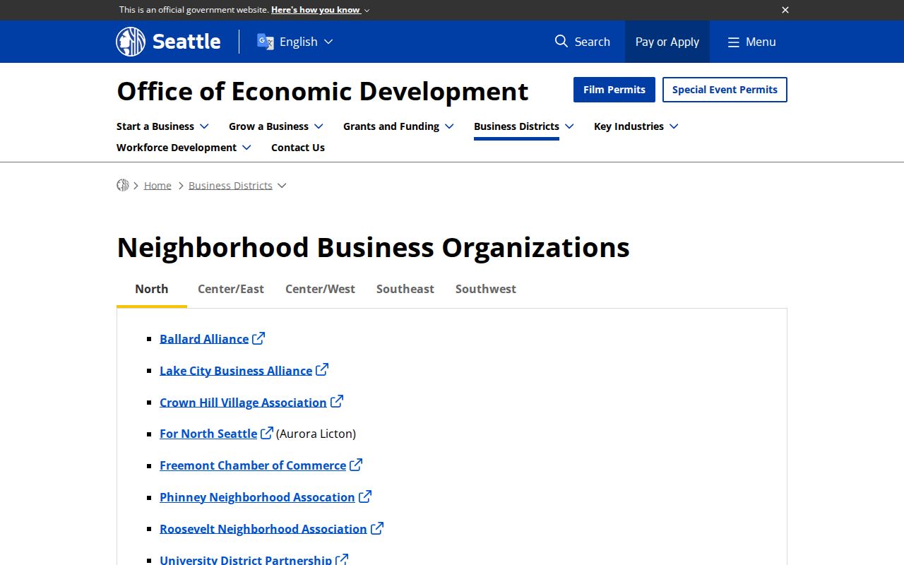
The inventory offers public names and area context. No verified public member roster was found, so it cannot identify individual neighbors.
Route Unincorporated King County Neighbors
Not every King County block belongs to Seattle or another city. The county organizes unincorporated communities through seven Community Service Areas: Bear Creek/Sammamish, Four Creeks/Tiger Mountain, Greater Maple Valley/Cedar River, Snoqualmie Valley/Northeast King County, Southeast King County, Vashon/Maury Island, and West King County.
White Center, Skyway, Fairwood, Roxhill, Top Hat, and Glendale are county examples. Use the parcel's jurisdiction report before routing a local question. County permit and code files generally apply only to unincorporated property; city blocks use their municipal offices. A ZIP label or preferred mailing city does not settle jurisdiction.
Historic King County Neighbors
Historical block work uses another record set. Seattle Municipal Archives holds an assessment-roll index for 1891 through 1911, arranged by street or addition, district, ordinance, and assessment volume. Reverse directories list names by street address, while property cards can preserve former numbers, former street names, photos, and construction detail.
A striking local source is the 1906 Southeast Seattle census finding aid, which names 4,282 residents. It is a dated community record, not a current roll. Ballard's municipal minutes cover 1890 through its 1907 annexation, so a historic address may sit under a former city's records. Match each old name to its year and jurisdiction.
Old maps, directory lines, census entries, and assessment rolls are historical listings. They do not show who lives on the modern block.
Compare King County Neighbor Tools
Official sources are narrower than commercial neighbor tools, but their claims are easier to define. Commercial services may merge names and addresses from unknown dates, hiding the reason for a match.
| Source type | Useful claim | Main limit |
|---|---|---|
| County GIS and Assessor | Parcel geometry and owner of record | Not current occupancy |
| Recorder and plats | Recorded parties and land relationships | Index is not the full document |
| Community organizations | Public contacts and area context | Not a resident roster |
| Commercial category | Possible leads from many sources | Dates, provenance, and accuracy may be unclear |
For civic curiosity or property research, retain the official URL, access date, PIN, and record label. That source log makes later corrections possible.
Privacy for King County Neighbors
Washington law does not turn each public field into an unrestricted block directory. King County's voter service is for an individual match, while bulk data follows a separate process under RCW 29A.08.710. Court files may seal juvenile, adoption, family, and other protected material. District Court public results omit addresses, phones, and dates of birth.
The Washington Address Confidentiality Program supplies qualifying participants with a substitute address and mail forwarding. The actual address is protected and cannot be recovered through an ordinary neighbor lookup. Its safeguards cannot be bypassed by combining sources.
Respect privacy. Use information about King County neighbors only for lawful personal and civic purposes. Never stalk, harass, intimidate, or expose a protected address.
Describe only what the source proves: neighboring parcel, owner of record, recorded party, historic listed resident, or public organization contact.